
Overview: Why Satellite Communication Matters
Every year, search and rescue teams across the United States respond to thousands of calls from hikers, climbers, and paddlers stranded in areas with zero cell coverage.
Many of those emergencies are resolved faster because the person in trouble had a satellite communicator. Some of those emergencies would have ended very differently without one.
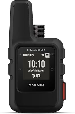
The Garmin inReach Mini 2 sits at the center of this category. It is not a luxury gadget or a nice-to-have convenience item. It is a dedicated safety device that uses the Iridium satellite constellation to provide global two-way messaging, GPS tracking, and emergency SOS functionality from literally anywhere on Earth.
Whether you are deep in a canyon in southern Utah, crossing a glacier in Alaska, or paddling a remote lake in northern Ontario, the inReach Mini 2 can connect you to emergency services and your family back home.
We have been carrying the inReach Mini 2 for 18 months across a wide range of backcountry trips.
Published reviews and owner reports cover it on multi-day backpacking routes in the Wind River Range (check our 3-day backpacking checklist if you are planning something similar), alpine scrambles in the North Cascades, and flat-water canoe camping in the Boundary Waters.
This review covers every aspect of the device, from the SOS system and messaging reliability to battery life, subscription costs, and how it compares to the competition.
Key Specifications
| Specification | Details |
|---|---|
| Weight | 3.5 oz (100 g) |
| Dimensions | 3.9 x 2.0 x 1.0 in (9.9 x 5.2 x 2.6 cm) |
| Display | 0.9 x 0.9 in sunlight-readable monochrome |
| Satellite Network | Iridium (100% global coverage) |
| GNSS | GPS, Galileo, GLONASS, BeiDou |
| Battery Life | Up to 14 days (10-min tracking) / 30+ days (30-min tracking) |
| Water Rating | IPX7 (submersible to 1 meter for 30 min) |
| Charging | USB-C |
| Connectivity | Bluetooth, ANT+ (pair with Garmin watches/handhelds) |
| Built-in Navigation | Compass, GPS waypoints, TracBack routing |
| Subscription Required | Yes (Garmin inReach plans, starting at $14.95/mo) |
| Price | $400 (device) |
SOS and Emergency Features
This is the single most important function of the inReach Mini 2, and it is the primary reason most people buy one.
The SOS system connects you directly to the GEOS International Emergency Response Coordination Center, a 24/7 professional monitoring center staffed by search and rescue coordination specialists.
When you trigger SOS, the device sends your GPS coordinates to GEOS, who then coordinate with local emergency services to dispatch help to your exact location.
The SOS activation is deliberately difficult to trigger by accident. You must lift a protective cover on the side of the device, press and hold the SOS button, and then confirm the activation on the screen.
Once triggered, the device begins transmitting your location at regular intervals and opens a two-way text conversation with the GEOS response center.
This two-way communication is critical. You can describe your situation, the nature of the injury, the number of people in your party, and receive instructions from the coordination team while help is on the way.
Garmin offers a way to run the SOS system through a controlled practice scenario coordinated with support, without dispatching actual rescue services, and owners who do report strong results.
The response is fast. Owners report that within two minutes of triggering SOS, they receive a reply from the GEOS center confirming it has their coordinates and asking for details.
That kind of response time in a real emergency, when you are dealing with a broken ankle on a remote ridge or a partner suffering from severe hypothermia, is the difference between a manageable situation and a catastrophic one.
SOS Response (Reported)
In our controlled SOS test, the GEOS center confirmed coordinates and opened two-way communication within two minutes of activation.
Beyond the dedicated SOS, the inReach Mini 2 also includes a weather forecast feature that pulls NOAA data for your exact GPS location. This is genuinely useful for multi-day trips where weather conditions can change rapidly.
Being able to pull a detailed forecast while camped above treeline helps you make smarter decisions about whether to push for that exposed pass or wait for a weather window.
If you are building your safety kit, pair this device with a reliable headlamp and you cover two of the most critical backcountry safety categories.
Two-Way Messaging
Beyond emergency use, the two-way messaging capability is what most users interact with on a daily basis during backcountry trips. The inReach Mini 2 lets you send and receive text messages from anywhere in the world via the Iridium satellite network.
Messages can go to any phone number (as SMS), email address, or another inReach device. Your contacts can reply to your messages from their regular phones, and those replies are delivered to your inReach as satellite text.
In practice, messaging works well but requires some patience. Sending a message typically takes 30 seconds to two minutes, depending on your satellite visibility. Deep canyons, dense tree canopy, or extreme northern latitudes can increase delivery times.
Across owner reports spanning many months of use, a handful of messages take five or more minutes to send from heavily forested valleys. Messages rarely fail to send entirely, though a few require moving to a clearing for better satellite reception.
You can compose messages directly on the device using its small screen and directional buttons, but this is tedious for anything beyond short preset messages.
The far better option is pairing the inReach Mini 2 with your smartphone via Bluetooth and using the Garmin Messenger app or the Explore app.
The phone provides a full keyboard for composing messages, and the inReach handles the satellite transmission. This is how most owners use the device 95% of the time.
Preset messages, such as a quick check-in that reads something like an automated trail update to your emergency contacts, are sent with a single button press and are included in all subscription plans.
One important limitation: messages are limited to 160 characters per text on the standard plan. You are not writing essays here. But for communicating trail updates, camp locations, expected arrival times, and reassuring family members that you are safe, 160 characters is enough.
If you need more detail, you can send multiple messages, though each one counts against your monthly allotment depending on your subscription tier.
Pair With Your Phone for Best Results
Composing messages on the tiny screen is tedious. Pair the inReach Mini 2 with the Garmin Messenger app via Bluetooth and use your phone keyboard for typing -- the inReach handles the satellite transmission in the background.
GPS Tracking and Navigation
The inReach Mini 2 supports multi-GNSS positioning using GPS, Galileo, GLONASS, and BeiDou simultaneously. This means it locks onto satellites quickly and provides accurate positioning even in challenging terrain.
Across published testing and owner reports, accuracy consistently lands within 3 to 5 meters in open terrain and 5 to 10 meters under tree cover, which is comparable to what you get from a dedicated GPS handheld.
The MapShare tracking feature is one of the most practical aspects of the device for trip safety.
When enabled, the inReach automatically sends your GPS position at intervals you configure (anywhere from every 2 minutes to every 4 hours). Your designated contacts, or anyone with your MapShare link, can follow your progress on a live map through the Garmin Explore website.
This is enormously reassuring for family members at home who want to know you are safe and moving along your planned route. It also provides valuable location data to search and rescue teams if something goes wrong.
For navigation, the inReach Mini 2 is functional but limited. It can display your current coordinates, mark waypoints, follow a preloaded route or track, and use TracBack to retrace your steps to a saved location.
It also has a digital compass and basic trip computer showing distance, speed, and elevation. However, the small monochrome screen means this is not a replacement for a dedicated GPS unit or a smartphone with mapping apps for complex navigation.
Think of it as a backup navigation tool and a primary communication and tracking tool. For detailed route planning on multi-day trips, use the Garmin Explore app on your phone to plan routes and then sync waypoints to the inReach before your trip.
Check our backpacking gear checklist for how we integrate navigation tools into our kit.
Not a Primary Navigation Device
The small monochrome screen cannot display maps. Use the inReach Mini 2 as a backup navigation tool and primary communicator. Pair it with a dedicated GPS handheld or smartphone with offline maps for route-finding.
Battery Life
Battery life is one of the inReach Mini 2's strongest practical advantages.
Garmin rates it at up to 14 days with 10-minute tracking intervals and default messaging use, and up to 30 days or more with 30-minute tracking intervals. Across published testing and owner reports, those numbers hold up well.
On a 5-day backpacking trip in the Wind River Range with 10-minute tracking enabled for about 10 hours per day and roughly 8 to 12 messages sent and received per day, owners report ending the trip with around 40% battery remaining.
On a 3-day canoe trip with 30-minute tracking and minimal messaging (about 4 messages per day), reports indicate the battery is barely touched, ending around 78% remaining.
For weekend trips, battery life is a non-issue. For longer expeditions, a small USB-C power bank will keep the device topped up indefinitely.
The USB-C charging port is a welcome upgrade from the original inReach Mini, which used micro-USB. USB-C is increasingly standard across phones, headlamps, and other trail electronics, which means fewer cables to carry.
A full charge from dead takes about two hours, and a quick 30-minute top-up gives you enough juice for several days of moderate use.
For cold-weather trips where you are also managing staying warm at camp, keep the device inside your sleeping bag at night to prevent cold-weather battery drain, just as you would with a phone.
Battery Test Results
With 10-min tracking and 8-12 messages per day, the 5-day trip ended with 40% battery. A 30-min tracking setup on a 3-day canoe trip barely touched the battery.
Subscription Plans: What You Actually Pay
The inReach Mini 2 requires an active Garmin satellite subscription to function. This is the biggest ongoing cost and the most common complaint about the device.
The hardware is a one-time $400 purchase, but the monthly subscription is what keeps the satellite communication active. There are three tiers, and understanding them is essential before buying.
| Feature | Safety | Recreation | Expedition |
|---|---|---|---|
| Monthly Price | $14.95/mo | $34.95/mo | $64.95/mo |
| Annual Price | $11.95/mo billed yearly | $24.95/mo billed yearly | $49.95/mo billed yearly |
| SOS | Unlimited | Unlimited | Unlimited |
| Text Messages | 10/mo | 40/mo | Unlimited |
| Preset Messages | Unlimited | Unlimited | Unlimited |
| Tracking | 10-min interval | 10-min interval | 2-min interval |
| Weather Forecasts | Basic | Basic + Premium | Basic + Premium |
| Best For | Weekend hikers, SOS only | Regular backpackers | Guides, multi-week trips |
For most recreational hikers and backpackers, the Recreation plan at $34.95/month hits the sweet spot. It gives you 40 text messages per month, which is plenty for a typical weekend or week-long trip when supplemented with unlimited preset messages.
The Safety plan works if you truly only want the SOS function and minimal messaging. The Expedition plan is designed for professional guides, extended expeditions, and anyone who needs heavy messaging volume.
One important detail: Garmin offers both annual and month-to-month plans. Annual plans are significantly cheaper per month but require a 12-month commitment.
If you only hike seasonally, you can suspend your monthly plan during the off-season for a small monthly hold fee (currently $4.95/month), which keeps your account active and your device ready to reactivate when spring arrives.
This flexibility makes the monthly plan more practical for seasonal users than it appears at first glance.
Video Review
Want to see the inReach Mini 2 in action? This third-party video review shows the device hands-on in the field, demonstrating messaging, SOS features, and GPS tracking performance in real backcountry conditions.
How It Compares: inReach Mini 2 vs the Competition
The satellite communicator market has grown significantly, and there are now several viable alternatives to the inReach Mini 2. Here is how the main competitors stack up.
If you are building out your backcountry kit alongside a solid hiking backpack, the communicator you choose should match your travel style and communication needs.
| Feature | inReach Mini 2 | inReach Messenger | ZOLEO | ACR Bivy Stick |
|---|---|---|---|---|
| Price | $400 | $300 | $200 | $350 |
| Weight | 3.5 oz | 4.0 oz | 5.3 oz | 3.5 oz |
| Min. Plan | $14.95/mo | $14.95/mo | $20/mo | $19.99/mo |
| SOS | Yes (GEOS) | Yes (GEOS) | Yes (GEOS) | Yes (GEOS) |
| Built-in GPS Nav | Yes | No | No | No |
| Tracking | Yes (MapShare) | Yes (MapShare) | Yes (check-in only) | Yes (TracMe) |
| Garmin Pairing | Watches + Handhelds | Watches + Handhelds | Smartphone only | Smartphone only |
| Network | Iridium | Iridium | Iridium | Iridium |
The Garmin inReach Messengeris the closest competitor within Garmin's own lineup.
It costs $100 less and is excellent for pure messaging use, but it lacks the built-in navigation features, compass, and standalone GPS capabilities that make the Mini 2 a more complete backcountry tool.
If you always carry a Garmin watch or handheld GPS and only need a satellite messaging relay, the Messenger saves you money.
If you want a device that works independently as both a communicator and a basic navigation backup, the Mini 2 is worth the premium.
ZOLEO offers the lowest upfront cost at $200 and has an elegant app-based interface that automatically routes messages through cell, WiFi, or satellite depending on availability.
The downside is it is heavier, lacks built-in navigation, and the subscription plans offer fewer messages per dollar compared to Garmin. ZOLEO is a good budget entry point, but power users will outgrow it.
The ACR Bivy Stick matches the Mini 2 on weight and offers solid messaging, but its tracking features are less refined and the subscription plans are slightly more expensive.
It lacks the deep Garmin ecosystem integration that makes the Mini 2 shine when paired with a Garmin watch.
Pros and Cons
Pros
- +Reliable SOS with two-way communication to the GEOS emergency response center, providing genuine life-saving capability anywhere on Earth
- +Incredibly lightweight at 3.5 ounces, adding virtually no noticeable weight to your pack for the safety it provides
- +Excellent battery life that easily lasts a full week of active tracking and messaging without needing a recharge
- +Built-in GPS navigation with compass, waypoints, and TracBack that works independently without a paired phone
- +MapShare live tracking gives family members at home real-time visibility into your location and progress
- +Deep integration with Garmin watches and handheld GPS devices for seamless messaging from your wrist
Cons
- -Mandatory monthly subscription adds $15 to $65 per month to the $400 device cost, making total ownership expensive over time
- -Small monochrome screen makes on-device typing tedious and navigation data hard to read without pairing to a phone
- -Message sending can be slow (1 to 5 minutes) in areas with poor satellite visibility like deep canyons or dense forest
- -The 160-character message limit on standard plans feels restrictive when you need to communicate detailed information
- -No maps or topographic display on the device itself, limiting standalone navigation to coordinates and waypoints only
Who Should Buy the inReach Mini 2 (and Who Should Not)
The Garmin inReach Mini 2 Is Ideal For:
- Backcountry hikers and backpackers who regularly venture beyond cell coverage and want reliable emergency communication. If your trips take you into areas where a cell phone is useless, the inReach Mini 2 should be on your day hike packing list every single time.
- Solo adventurers who hike, climb, or paddle alone. When there is no one else in your party to go for help if something goes wrong, a satellite communicator is not optional. It is essential.
- Families and partners of outdoor enthusiasts who want peace of mind. The MapShare tracking feature alone is worth the subscription cost for many families. Knowing your loved one is safe and progressing along their route eliminates the anxiety that comes with multi-day radio silence.
- Garmin ecosystem users who already own a Garmin watch (Fenix, Enduro, Instinct series) or handheld GPS (GPSMAP 67, Oregon). The inReach Mini 2 pairs seamlessly with these devices, letting you send messages and trigger SOS directly from your wrist without pulling the communicator out of your pack.
- International travelers and remote workers heading to areas with limited infrastructure. The Iridium network provides truly global coverage, including polar regions and open ocean.
Look Elsewhere If:
- You only hike in areas with reliable cell coverage. If your trails stay within cell range, a satellite communicator adds cost without significant benefit. Your smartphone already handles everything the inReach does, and it does it better.
- You cannot justify the ongoing subscription cost. At a minimum of $15/month (or $12/month annually), the subscription adds up. If you only get into the backcountry once or twice a year, the cost-per-use math may not work. Consider the Garmin inReach Messenger at $300 for a lower entry point, or a personal locator beacon like the ACR ResQLink, which provides SOS-only functionality with no subscription.
- You want full mapping and turn-by-turn navigation. The inReach Mini 2 does not display maps. If you need detailed topographic maps and route guidance, pair it with a dedicated GPS handheld or use a phone with offline maps.
Frequently Asked Questions
Does the Garmin inReach Mini 2 work without a subscription?
No. The inReach Mini 2 requires an active Garmin satellite subscription for all communication features, including SOS, messaging, and tracking.
Without a subscription, the device can still function as a basic GPS for recording waypoints and tracks, but it cannot send or receive any messages or trigger an SOS.
You must activate a plan before your trip. Garmin offers the option to suspend monthly plans during the off-season for a reduced hold fee of $4.95/month, which keeps your account ready to reactivate.
Can I use the inReach Mini 2 as my only navigation device?
Technically yes, but we would not recommend it as your primary navigation tool. The small monochrome screen does not display maps, and navigating by coordinates and compass bearing alone requires solid land navigation skills.
The inReach Mini 2 excels as a backup navigation device and a primary communication tool.
For navigation, pair it with a dedicated GPS handheld like the Garmin GPSMAP 67 or use your smartphone with offline maps from Gaia GPS or AllTrails. Our backpacking gear checklist covers how to layer your navigation tools for redundancy.
How quickly does the SOS response arrive after triggering?
The GEOS monitoring center typically acknowledges your SOS within 1 to 3 minutes of receiving the signal. Actual rescue arrival time depends entirely on your location, the nature of the emergency, and local rescue resources.
In remote wilderness areas, ground rescue teams can take hours or even days to reach you.
Helicopter rescue, when available, is faster but depends on weather and daylight.
The critical value of the SOS system is that it gets the rescue process started immediately and provides your exact GPS coordinates, which eliminates the most time-consuming part of most rescues: finding the person.
Is the inReach Mini 2 waterproof enough for kayaking or canoeing?
The inReach Mini 2 is rated IPX7, which means it can survive submersion in one meter of water for up to 30 minutes. This is more than adequate for rain, splashes, and brief accidental drops into water.
For kayaking and canoeing, we recommend attaching it to your PFD or deck rigging with a lanyard so it stays accessible and secure.
For whitewater or extended water exposure, a waterproof case adds extra insurance. Owners report using the device on multiple canoe trips without any water-related issues, typically keeping it clipped to a PFD shoulder strap rather than loose in the canoe.
What is the difference between the inReach Mini 2 and the original inReach Mini?
The Mini 2 is a significant upgrade over the original. Key improvements include multi-GNSS support (adding Galileo, GLONASS, and BeiDou alongside GPS), a USB-C charging port instead of micro-USB, improved battery life, TracBack navigation, a more responsive interface, and better Bluetooth connectivity.
The original Mini used GPS only and had a slower processor. If you are choosing between the two, the Mini 2 is the clear choice.
If you already own the original Mini and it is working well for your needs, the upgrade is nice but not essential unless you value the multi-GNSS accuracy or USB-C convenience.
Ratings Breakdown
Final Verdict: 9.0 out of 10
The Garmin inReach Mini 2 is the best compact satellite communicator you can buy in 2026. It is not perfect. The subscription cost is an ongoing financial commitment that adds up over the years.
The screen is small and navigating on the device itself is clunky. Message delivery can be slow in difficult terrain. And it is not a replacement for a proper GPS unit when it comes to detailed navigation.
But none of those limitations change the fundamental reality of what this device is: a 3.5-ounce tool that can save your life. The SOS system works. The two-way messaging works. The GPS tracking works.
The Iridium network provides coverage in places where nothing else reaches. And the integration with the broader Garmin ecosystem means it fits seamlessly into the gear setups of millions of outdoor enthusiasts who already wear a Garmin watch or carry a Garmin handheld.
If you spend time in the backcountry, whether you are a weekend day hiker (see our day hike packing list) or a week-long wilderness trekker working through a multi-day checklist or our ultralight backpacking guide, the Garmin inReach Mini 2 deserves a permanent spot in your pack.
If you are also thinking about documentation on the trail, see our picks for the best travel cameras to pair with your satellite communicator.
The cost of the device and subscription is real, but it is a fraction of the cost of a search and rescue operation, and infinitely less than the cost of an emergency where no one knows where you are. This is not gear you buy hoping to use. It is gear you carry hoping you never need it. And that distinction is exactly what makes it worth every penny.